Baltoro Glacier Trek: A Complete Guide to the Road to K2
· Broad Peak Adventures
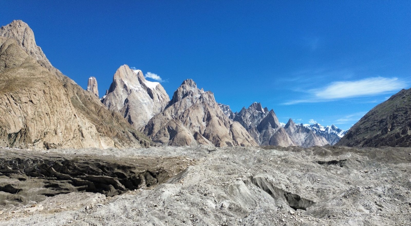
Every trek to K2 Base Camp has one thing in common: a week on the Baltoro Glacier. There is no road to K2, no shortcut and no lodge on the way. You walk up a river of ice and rock for roughly sixty kilometres, past some of the tallest granite walls on the planet, until the glacier opens out at Concordia and K2 finally appears at the head of the valley.
This guide covers what the Baltoro Glacier trek is actually like on the ground. Where the glacier is, how the route works camp by camp, which peaks you pass, how hard the walking is, when to go and what you need to arrange before you set off.
Where is the Baltoro Glacier?
The Baltoro Glacier lies in the Shigar District of Gilgit-Baltistan, in the far north of Pakistan, inside the Central Karakoram National Park. It runs east to west through the heart of the Karakoram range, with the Baltoro Muztagh peaks on its north side and the Masherbrum group to the south.
It is about 63 km long and drains an area of around 1,500 square kilometres, which makes it one of the longest glaciers anywhere outside the polar regions. Glaciologists measure the main tongue from the Conway Saddle at about 6,200 m down to its snout near Paiju at about 3,400 m. Its average width is around two kilometres, and it spreads to more than three kilometres near Goro I.
For trekkers, what matters is simpler. The snout of the Baltoro is the doorway to K2, and almost every expedition to K2 from the Pakistan side has walked the same line up the ice.
The Baltoro Glacier trek route, camp by camp
The trek starts at Askole, the last village in the Braldu valley, a long jeep ride from Skardu through the Shigar valley. From Askole it takes about seven walking days to reach Concordia, including one rest day for acclimatisation. These are the standard camps and the altitudes we use on our trips.
- Askole (3,050 m). The road head and the last village. Porters are hired and loads are weighed here.
- Jhola (3,200 m). A hot, dusty day along the Braldu River, with the first big Karakoram walls appearing ahead.
- Paiju (3,380 m). The last green campsite before the ice, with willow trees and the first view of the Baltoro snout. Many groups take their rest day here or at Urdukas.
- Khoburtse (3,760 m). The first day on the glacier itself. You climb onto the snout and follow the moraine, with Uli Biaho and the Trango group rising on the left.
- Urdukas (4,130 m). Grassy terraces above the ice and one of the finest viewpoints of the trek, looking straight across at the Trango Towers and the Cathedral peaks.
- Goro II (4,250 m). Camp in the middle of the glacier. Masherbrum, Gasherbrum IV and Mitre Peak start to dominate the view.
- Concordia (4,600 m). The meeting point of the Baltoro and Godwin-Austen glaciers, with K2 straight ahead.
From Concordia most groups walk on to Broad Peak Base Camp and K2 Base Camp at about 5,150 m. Our Baltoro Glacier and K2 Base Camp Trek sleeps a night at Broad Peak Base Camp rather than trying to reach K2 and come back to Concordia in one long day, which gives you a far better chance of actually standing at the foot of K2.
The peaks you pass on the Baltoro
Part of what makes the Baltoro so famous is the parade of mountains on both sides. In order of appearance, these are the ones trekkers talk about most.
- Paiju Peak and Uli Biaho Tower. The first big walls, seen from Paiju and the snout of the glacier.
- The Trango Towers. Great Trango rises to about 6,286 m, and the slender Nameless Tower is one of the most famous big wall climbs in the world.
- The Cathedral group. Rows of granite spires opposite Urdukas.
- Masherbrum (7,821 m). The first peak on the 1850s survey list of the Karakoram, which is why it was once called K1.
- Mitre Peak, Muztagh Tower and Gasherbrum IV (7,925 m). Gasherbrum IV glows gold in the evening and fills the view from Goro II.
- Broad Peak (8,051 m) and K2 (8,611 m). The two 8,000 m giants that greet you at Concordia, with Chogolisa to the south.
The letter names come from the British survey of the 1850s, when Thomas Montgomerie labelled the peaks he could see K1, K2, K3 and so on. Most later received local names. K2 kept its survey number, and we explain the full story in why K2 is called K2 on the Broad Peak Adventures blog.
What walking on the Baltoro is really like
People often imagine a glacier trek as walking on clean white ice. The lower Baltoro is nothing like that. For the first few days the ice is buried under a thick layer of rock and gravel, so you walk up and down over grey and brown moraine ridges, around meltwater pools and across small streams. The path changes every season as the ice moves.
The walking is rarely steep, but it is relentless. Expect five to seven hours a day on uneven ground, with the altitude slowly climbing from just over 3,000 m to 4,600 m. The heat can be surprising at the start, especially between Askole and Paiju, and the nights get colder the higher you go. By Concordia you will be wearing a down jacket as soon as the sun drops.
You camp every night. A good crew sets up a mess tent, cooks three hot meals a day and carries water, fuel and food for the whole trek. Balti porters carry the loads, and their skill and good humour on the moraine is one of the things trekkers remember most about the Baltoro.
How hard is the Baltoro Glacier trek?
The Baltoro Glacier trek needs no climbing skills. You do not need ropes or crampons on the standard route to Concordia and K2 Base Camp in summer. What it does need is stamina, good boots and the patience to walk on broken ground for many days in a row.
We grade it as strenuous. If you have done a multi day trek at altitude before, such as a long route in Nepal or the Andes, and you train for several months beforehand, you are in a good position. If this would be your first trek of any kind, it is worth building up with shorter mountain trips first.
Altitude is the other challenge. The itinerary climbs gradually and includes a rest day, but everyone acclimatises at a different speed, so it is important to walk slowly, drink plenty of water and tell your guide early if you feel unwell.
Best time for the Baltoro Glacier trek
The trekking season on the Baltoro runs from June to September. July and August usually bring the most settled weather and coincide with the climbing season on K2 and Broad Peak, so base camps are busy with expeditions. June can still have snow higher up the glacier, and September brings clear, cold days with fewer people.
Outside summer the Baltoro is a very different place. It is possible to trek in winter with a well equipped private team, but the conditions are serious. Our Winter K2 Trek explains what changes when the glacier is frozen and under snow.
Permits, guides and logistics
The Baltoro is inside a restricted zone of the Central Karakoram National Park, so independent trekking is not allowed. Foreign trekkers need a trekking permit, national park fees and a licensed local operator and guide, all arranged before you arrive. Gilgit-Baltistan has changed its permit and fee rules more than once in recent years, so ask your operator for the current figures when you book rather than relying on old blog posts.
Most trips begin with a flight from Islamabad to Skardu, which takes about an hour and depends on clear weather. If the flight is cancelled, the backup is the long drive on the Karakoram Highway, so good itineraries build in spare days. From Skardu, jeeps take you on to Askole.
Please treat the glacier with care. Everything carried in should be carried out, and the campsites on the Baltoro have improved a lot since waste management schemes started. Choose a team that takes its rubbish back to Skardu and looks after its porters properly.
Baltoro Glacier treks we run
All of our K2 treks follow the Baltoro Glacier to Concordia. The difference is what you do after that.
- Baltoro Glacier and K2 Base Camp Trek. 21 days on the classic route to Concordia and K2 Base Camp and back.
- K2 Base Camp Trek. Our original 21 day itinerary with a night at Broad Peak Base Camp and a spare day at Concordia.
- K2 Base Camp and Gondogoro La Trek. Reach K2 Base Camp, then cross the 5,585 m Gondogoro La and walk out through the Hushe valley instead of retracing your steps.
For more on the place at the top of the glacier, read our guide to Concordia, the Throne Room of the Mountain Gods.
Frequently Asked Questions
How long is the Baltoro Glacier?
The Baltoro Glacier is about 63 km long, measured from the Conway Saddle at around 6,200 m down to its snout near Paiju. It is one of the longest glaciers outside the polar regions.
How many days does it take to trek the Baltoro Glacier?
From Askole it usually takes six to seven walking days to reach Concordia, including a rest day, and four to five days to walk back out. A full trip from Islamabad to K2 Base Camp and back takes about 20 to 21 days.
Do you need a guide to trek the Baltoro Glacier?
Yes. The Baltoro is in a restricted zone, so foreign trekkers need a permit and a licensed local operator and guide. Independent trekking is not allowed.
Is the Baltoro Glacier trek suitable for beginners?
It is not technical, but it is long, remote and at high altitude. It suits fit trekkers with some multi day trekking experience. Complete beginners should build up with shorter treks first.
Is there phone signal on the Baltoro Glacier?
Do not count on it. Coverage becomes patchy after Askole and is often missing on the glacier. A good operator carries a satellite phone for emergencies.